- Phone : +92 62-925-5579
- Email : addl.dir.dost@iub.edu.pk
- Work Hours : Mon - Fri : 09:00 - 18:00
Tourism
Wildlife Tours
Syed Muhammad Uzair Gardezi is son of soil of famous Gardezi family of Bahawalpur region. He was born in Karachi and latter joined Sadiq Public School and eventually graduated in 1985. He interest in wild life from prompted him to take up photography as profession as he got himself recognized as wild life nature photography 1983. He won all Pakistan gold trophy for nature in 1996(PASP FROM). He was opened new tourism chapter for Bahawalpur region by photographing very rear species of animals and birds found only in this region.
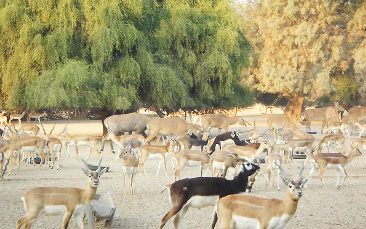
Lal Suhanra National Park
Lal Suhanra is a national park in Pakistan that is situated in the Bahawalpur district of Punjab province. It is one of South Asia’s largest nationals parks, and is a UNESCO declared Biosphere Reserve. Lal Sohanra is notable for the diversity of its landscape, which includes desert, forest and wetland ecosystems.
There are archaeological remains of the ancient Indus valley civilization which once flourished along the Ghaggar-Hakra River (paleo Saraswati River). Lal Suhanra National Park is situated some 35 kilometres east of Bahawalpur and presents a synthesis of forest and desert life. It occupies land on both sides of Desert Branch canal, and is spread over an area of 127,480 acres (51,368 hectares) – out of which 20,974 acres (8,491 hectares) are green land (irrigated plantations), 101,726 acres (40,942 hectares) are dry land (desert), and 4,780 acres are wet land (ponds and lakes). The park’s terrain is generally flat, interspersed with sand dunes measuring between 1 and 6 meters in height and occupying as many as thousands of acres apiece.
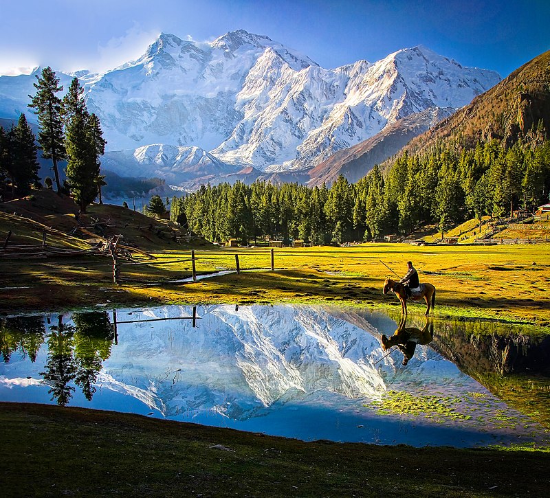
Fairy Meadows National Park
Fairy Meadows named by German climbers (German Märchenwiese, “fairy tale meadows”) and locally known as Joot, is a grassland near one of the base camp sites of the Nanga Parbat, located in Diamer District, Gilgit-Baltistan, Pakistan. At an altitude of about 3,300 metres (10,800 ft) above sea level, it serves as the launching point for trekkers summiting on the Rakhiot face of the Nanga Parbat. In 1995, the Government of Pakistan declared Fairy Meadows a National Park.
Fairy Meadows is approachable by a fifteen kilometer-long jeepable trek starting from Rakhiot bridge on Karakoram Highway to the village Tato. The dangerous and narrow gravel mountain road from the bridge to the village is only open to locals, who provide transportation to visitors. In 2013, the World Health Organization declared it the second-deadliest road on the planet.
Deosai National Park
The Deosai National Park is a high-altitude alpine Plain (plateau) and National Park located in between Skardu, Astore and Kharmang district in Gilgit Baltistan. Most of the area falls in Skardu district. Deosai Plains are situated at an average elevation of 4,114 metres (13,497 ft) above sea level and considered as the second highest plateaus in the world. The name came about from the folk tale immortalised by Mian Muhammad Baksh in his poem, “Saif al-Mulook”; the word ‘Deosai’ means ‘the Shadow of the Giant’: the word “Deo” being a contraction of ‘Deva’, and the word ‘Sai’ being one of ‘Saya’ i.e. ‘Shadow’.Sai or Sain also an acronym for swami or lord.
The Deosai National Park is located in western Himalayas in Gilgit Baltistan (GB), Pakistan. It has an average elevation of 4,114 metres (13,497 ft) above sea level, making the Deosai Plains the second highest plateau in the world after Changtang Tibetan Plateau. The park protects an area of 843 square kilometres (325 sq mi).

Chitral National Park
Chitral Gol National Park is one of the National Parks of Pakistan. It is located in Chitral District in Khyber-Pakhtunkhwa province of Pakistan beside the Chitral River, at a distance of two hours drive from Chitral town. The park is also known as Chitral National Park. Up until 1983, Chitral Gol was considered to be the private property of the former Mehtar of Chitral. The status of the park has been in dispute since and has become the issue of ongoing litigation between heirs of the former Mehtar and the Government of Pakistan.
This park includes three valleys. Several glaciers also lie in the park through which several springs make their way and ultimately form a stream which runs 18 kilometres. The cold water of this stream flows towards the east, into the River Chitral.
Ayubia National Park
Ayubia National Park also known as Ayubia, is a protected area of 3,312 hectares (33 km2) located in Abbottabad District, Khyber Pakhtunkhwa province, Pakistan. It was declared a national park in 1984. Ayubia was named after Muhammad Ayub Khan (1958–1969), second President of Pakistan. The area supports temperate coniferous forest and temperate broadleaf and mixed forest ecoregion habitats, with an average elevation of 8,000 feet (2,400 m) above sea level. Ayubia National Park is surrounded by seven major villages and three small towns of Thandiani, Nathiagali and Khanspur. The park has been developed as a resort complex from a combination of four mini resorts of Khaira Gali, Changla Gali, Khanspur and Ghora Dhaka in Galyat. Currently, it is managed by the Wildlife and Parks Department of Government of Khyber Pakhtunkhwa.
The climate of the park is cool in the summers, but harsh in the winters. While it remains only placidly hot in May and June, the cold sets in when the monsoons come to lash in late July and early August.
Subscribe & Follow us
Subscribe & Get More Information
Get IUB-DoST news and updates.

IUB-DoST is to integrate all aspects of tourism & hospitality development and management rather than being an add-on component.
- Phone : +92 62-925-5579
-
Address: Islamia University of Bahawalpur
Baghdad-ul-Jadeed Campus


 Users Today : 14